Wednesday December 4, 2019
By Rob Gutro 
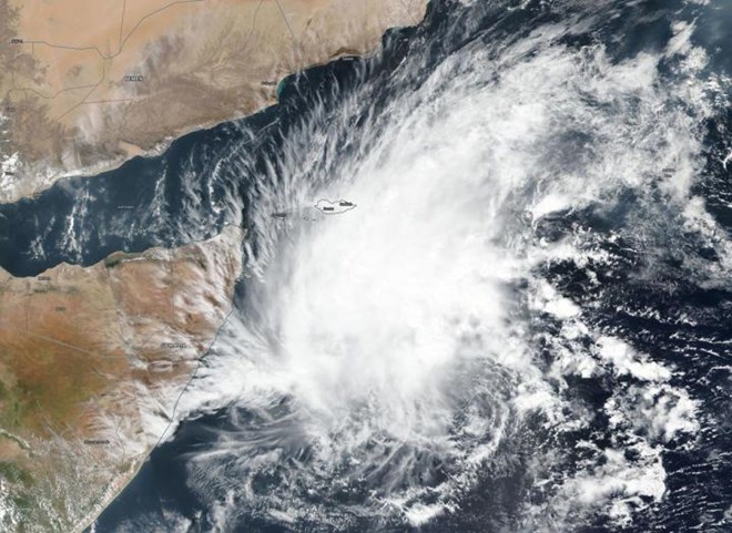
NASA-NOAA's Suomi NPP satellite passed over Tropical Cyclone 06A in the Arabian Sea on Dec. 3 and a visible image of 06A that revealed powerful storms were northwest of the center of circulation. The center of circulation is apparent in the VIIRS image as a small area of circulation located southeast of the bulk of clouds and showers. Credit-NASA Worldview, Earth Observing System Data and Information System (EOSDIS)
Imagery from NASA-NOAA's Suomi NPP satellite showed that a tropical depression in the Arabian Sea has consolidated and organized despite facing wind shear. Tropical Depression 06A is now Tropical Cyclone 06A.
The Visible Infrared Imaging Radiometer Suite (VIIRS) instrument aboard Suomi NPP provided a visible image of 06A that revealed powerful storms were northwest of the center of circulation, but the storm was able to strengthen despite the harsh environmental conditions. The center of circulation is apparent in the VIIRS image as a small area of circulation located southeast of the bulk of clouds and showers.
The Joint Typhoon Warning Center or JTWC in Pearl Harbor, Hawaii noted, "A fully exposed low level circulation center in animated multispectral satellite imagery. Strong (20-30 knot/ 23 to 34.5 mph /32 to 55.5 kph) vertical wind shear is offsetting good poleward outflow and warm (28 to 29 degrees Celsius/82.4 to 84.2 degrees Fahrenheit) sea surface temperature, hampering intensification." Tropical cyclones require sea surface temperatures of at least 26.6 degrees Celsius (80 degrees Fahrenheit) to maintain strength or intensify, so the warmer sea surface temperatures are allowing 06A to maintain its strength.
JTWC noted that at 10 a.m. EST (1500 UTC) on Dec. 3, that 06A had maximum sustained winds near 35 knots (40 mph/65 kph). 06A was located near latitude 7.1 degrees north and longitude 57.4 degrees east. It was about 784 nautical miles east-northeast of Mogadishu, Somalia.
It is moving to the northeast, however, and the track will slowly turn west southwestward as a subtropical ridge (elongated area of high pressure) builds back in to the north.
Tropical Cyclone 06A is forecast to make landfall in east central Somalia on Dec. 6 as a tropical storm.
Tropical cyclones and hurricanes are the most powerful weather events on Earth. NASA's expertise in space and scientific exploration contributes to essential services provided to the American people by other federal agencies, such as hurricane weather forecasting.